Trip Planning & Preparation
Study Guide
What to Know About Trip Planning & Preparation
This section covers topics such as weather, towing and fueling your boat, launch ramp etiquette and float plans. We’ll also go over the basics of planning a successful day on the water and the dangerous effects of mixing alcohol and boating.
Operator Responsibilities
Understanding Your Responsibilities to Guests and Other Boaters
When a guest steps aboard, the typical boat owner is more likely to be thinking more about having lunch or getting underway than worrying about his responsibilities as “Master” of the vessel. But if that guest were to stumble and be injured, you can bet the boat owner would quickly ponder what, if anything, could have been done to have prevented the injury and, heaven forbid, whether he might be liable.
The question of liability is both simple and complex, steeped in more than 3,000 years of maritime legal principles dating back to the Phoenicians. Admiralty law, like land-based legal concepts, starts with the premise that a property owner owes his invited guest a duty to exercise ordinary or reasonable care for the safety of the guest.
Deciding just what constitutes reasonable care can be especially complicated on a boat, which is bobbing, slippery and filled with obstructions. It has a great deal to do with the experience of the boat owner and the boating experience of the passenger and whether the boat owner had or should have had knowledge or notice of some dangerous condition. Additionally, it may depend on whether the owner knew or should have known his guest was unaware of or unfamiliar with the condition.
The duty to exercise reasonable care is rooted in the duty to provide a reasonably safe boat for the invited guest. This does not require that the boat be accident proof. Under the law, the applicable standard of care requires the boat owner to provide a boat that is reasonably safe, not one that is absolutely safe.
A guest also has some responsibility – a duty to exercise care for his or her own safety. A guest cannot simply walk blindly about the boat. But reasonable care does mean that you may be held accountable if you fail to warn a guest, for example, about a ladder you know is unstable.
Here is an example of an insurance claim to illustrate responsibility: A skipper invited an acquaintance to come by and inspect the aging sport fisherman he’d been fixing up for two years. Like most boats that are being restored from the keel up, the old boat was loaded with half-finished projects – wiring, cabinetry, engines, etc. The friend arrived while he was in the engine room puttering with the wiring. After a quick “yoo-hoo,” the friend started down into the main saloon but fell when the ladder slipped out from an unsecured fitting.
The friend wound up in the engine compartment only a few inches from the skipper. The friend’s injuries were neither serious nor permanent, but the skipper knew of the hazard and failed to warn his guest, which meant that he may well have been liable if the case had gone to court.
What about a clearly visible hazard such as an uncovered hatch? The law call this “open and obvious” danger, but courts have had trouble agreeing on whether you have to give someone a warning in the face of such a known risk. Some judges have ruled that the duty to warn is not imposed when you have an open and obvious condition since, under a standard of reasonable care, everyone is equally able to see the hazard. Other courts, however, have ruled that your invited guest may not appreciate the risk of what you believe is a readily apparent danger. Even more to the point, however, is the practical reality of ever-increasing numbers of lawsuits. Not only are lawsuits expensive, they are time consuming and take a tremendous emotional toll. Whatever legal comfort you might get in thinking that the danger is obvious, the reality is that the situation in the legal world today instructs you should always err on the side of giving a warning.
As an experienced skipper you know that a boat can pitch suddenly when it goes through a wake or comes about. You know to hang on until the boat is steady again. But these situations may be new and hazardous to a guest.
Clearly then, as skipper, you have the responsibility to warn an unsuspecting guest when you are aware of a hazardous situation on your boat. Further, you have a responsibility to warn guests about possible risks that are unrelated to your boat, but which are all around you: passing boat wakes, severe weather, tidal changes, etc. And, even if you are unaware of a loose railing, wobbly step, etc. or you don’t see an approaching boat wake, you may still be liable for any injuries that result.
And finally, operator responsibility extends to those guests and other waterway users that are in the water. Unfortunately, propeller strikes are a common source of injury and even death. As an operator, beware and use extreme caution when people are in the water and turn off your engine anytime a person is in the water and within one boat length of the boat. Also, it is advisable to educate your guests about the dangers of swimming around a boat and how to re-board the boat properly so as to avoid injury.
Remember then, the next time you welcome someone aboard, that an injury is more likely than ever to result in a lawsuit that, win or lose, could cost a fortune. When you also consider the many months of lost time and emotional strain you would live with, it might be wise to remember what a philosopher once said: “Be bold with your caution.”
Preparing for a Safe Trip
“When you call the Coast Guard…you are asking them to risk their lives to save yours. The rescuers…value their lives as much as we value ours. It is the duty of those who go to sea to avoid getting into situations that require the aid of the rescue services–heed the season, equip your vessel properly, keep a sharp eye for weather changes… don’t expect your ship to do something she can’t, pump for your life if you’re sinking, maneuver your vessel if you’re not. Think ahead. Anything less and you will be asking more of others than you ask of yourself.“
The Abandonment of the John F. Leavitt by Peter Spectre, WoodenBoat Magazine
When the weather is nice, or time is running short, we often take shortcuts to get onto the water as soon as we can. Most times, things work out just fine and we’re soon back at the dock or the launch ramp at the end of the day. But sometimes things go wrong–from an engine running out of gas to conking out–to the tragic deaths of loved ones. (To learn about the unfortunate sinking of the Morning Dew, visit the BoatU.S. damage avoidance magazine, Seaworthy).
Having a safe and enjoyable boating trip begins well before you step aboard the boat. No matter what the weather is before you start your trip, and no matter what your boating experience is–any trip can go differently than you first plan. The following excerpts are taken from Water Wise–Safety for the Recreational Boater, printed by the University of Alaska Sea Grant and available through BoatU.S.
For many people, their only boating experiences come from being a guest on boats such as yours. As a “boating ambassador” the more you can do to put them at ease, the better. Show them around the boat, show them how to use equipment, and what they can expect when they go out on the water. Share your knowledge with them–you will help them be safer on the water, and you will help them enjoy the water that much more.
Seven Factors
Before you step aboard your vessel, there are seven factors that you should think about to ensure a safe trip for you, your crew, and your boat.
1. Know Your Boat
It may seem fairly obvious that you need to “know your boat” before you go out…but think about it–how familiar are you really? Most people only go out on their boats when its sunny and the weather is nice. But what happens when something breaks, or the weather turns bad? Can you handle an emergency? Have you even prepared for an emergency? Some things to think about include:
- Do you know how your boat handles in rough weather?
- Can you get around your boat–and find things easily in the dark?
- Do you know how to access all of the through-hull fittings and remote compartments?
- Can you easily make minor repairs to the engine or steering systems?
- Can you easily find and operate emergency equipment such as the fire extinguisher?
2. Who Will Be Aboard
So who is going with you? A trip with five adults would be a great deal different from one with two adults and three preschoolers. Preparing for your guests is not only the courteous thing to do, but the safe thing to do. And don’t forget, as the captain you have a legal responsibility to provide for the safety and well being of those you bring aboard. Things to think about include:
- Do you have a pre-departure or safety “checklist” and have you discussed it with guests prior to departure?
- Did you inform your guests as to where life jackets and other safety gear are stowed?
- Do your guests have boating experience?
- Can your guests take over the boat/operate equipment in an emergency?
- Do you have spare clothes/raingear for your guests?
- Do you have enough food and water for your guests?
- Do any of your guests have medical conditions?
- Can your guests swim?
- Do your guests get sea-sick?
- Will you or your guests be drinking alcohol?
- Are there hazards that children should stay away from?
3. Where Are You Going
Are you planning a short trip across the lake or harbor? An all-day sailing or fishing trip? Or are you going off-shore for an extended cruise? More importantly, does anyone ashore know your plans? Planning your trip route before you leave will help you determine what additional gear you might need to bring, and may help you realize that the trip may be too dangerous to undertake at that time.
- Is your route along a busy waterway? If not, you might want to make sure your fuel tanks are topped off, and you have a radio to contact others. Keep in mind that busy waterways are usually just the opposite in the off-season!
- If you are going to a different port, does it have the facilities necessary to fix your boat, or facilities to treat a sick crew member?
- Will you be going with other boats, or meeting up with anyone?
- Most importantly, who have you left a float plan with?
4. Your Environment
Just because it is sunny and calm outside doesn’t necessarily mean the trip will go without a hitch. Weather has a nasty habit of changing with little warning. Thunder storms, high winds, fog, and other “weather events” can put a damper on your trip. Unseen factors include the tide and current–will there be enough water to get through a shallow channel? And don’t forget water temperature–even if the air temperature is warm, the water may be colder–given enough time, hypothermia will occur in even the warmest of waters. Clothing is your first line of defense against the elements. Dress for the water temperature–not the air temperature! While cotton clothing may be comfortable–especially in warmer weather–synthetic clothing such as POLYPROPYLENE helps retain body heat better. Wearing a hat is also a smart thing to do–they protect you from the sun, and help retain body heat.
- Are you wearing appropriate clothing for the weather conditions?And do you have spare clothing in case you get wet?
- Have you seen the weather report for your area? Do you have a radio to listen to the weather report while you are on the water?
- Have you brought sunscreen to prevent sunburn, and plenty of fluids to avoid dehydration?
- What is the water temperature–and can you survive for long if you fall in?
- Can you and your crew handle rough weather? Will anyone become sick or incapacitated?
- Will you be traveling in the evening? If so, do you have lights, and are the lights working? Do you have nighttime signaling devices or reflective materials on your clothing?
5. Equipment Issues
Properly equipping your boat with the appropriate gear can make a great day even better–and can make a bad day survivable. Proper equipment really depends upon the boat that you are on–row boats on a pond need different equipment than an ocean going vessel. All vessels must adhere to State and Federal minimum carriage requirements. Knowing what kind of trip you are taking, and where you are going will help you determine what extra equipment to bring along.
- If you are going far from shore or other boaters, do you have (and know how to use) a VHF radio and navigation equipment such as a compass, loran/GPS?
- Do you have usable, properly sized and fitted life jackets for everyone? While life jackets come in a variety of prices, styles and performance abilities–the life jacket that is worn is the best one to have. How much is your life worth? Over 80% of the people who drown each year weren’t wearing a life jacket!
- Do you have spare parts, lube oil, or gasoline?
- Do you have extra water, food and clothing for you and your crew?
- Do you have a first-aid kit?
- If you are going off-shore, do you have an EPIRB, raft, or survival suits? EPIRBS are available for rent from the BoatU.S. Foundation. Visit our EPIRB page for more information.
- Do you have even a small survival kit or “ditch bag”? Keeping a small, handy kit stocked with items such as garbage bags/emergency blankets, waterproof matches, cordage, a tarp and first aid kit can keep you going. Offshore kits should have extra food and water, a fishing kit, extra flares/signaling devices and medicines.
6. What Can Go Wrong
Planning ahead means considering what could go wrong, and thinking of how you as the skipper will handle it–or how you crew will handle it if something happens to you! Prudent skippers not only have a plan that they stick to, they also make sure the crew knows the plan, and can act accordingly in case of an emergency. When your guests come aboard, it’s time to share information with them about your boat, and about your trip. The information you need to share in this orientation will depend on your boat and how complicated things are.
Finally, make sure that someone ashore knows where you are going, and when to expect you back. Here is a simple float plan, provided to help you determine what information is helpful to rescue personnel. Leave your float plan with a responsible relative or friend–don’t file your float plan with the Coast Guard! STICK TO YOUR PLAN!
7. Your Responsibilities
As the captain, YOU are responsible for the safety of you, your passengers, your boat–and those you may come into contact with. This means that even the noise your boat makes or the wake your boat puts out can have an impact on other boats or property–so you are responsible. Your responsibilities are essentially a summary of the previous factors:
- You are responsible for knowing and adhering to the federal Rules of the Road, and all state and local boating laws.
- You are responsible for operating in a manner that is appropriate for the conditions–meaning going at no-wake speeds where required, operating at a safe boat speed in congested waters or at times of restricted visibility such as at night.
- You are responsible for the safety of the people on your boat, and you are required by the Rules to assist others in need if you can safely do so.
- When operating around swimmers and skiers, and others that may be in the water, you must always maneuver in a safe manner and be aware of the dangers of striking them with a miving propeller. Always place engine in neutral, or more preferably, stop your engine completely before someone moves to re-board the boat.
Boating is a great way to enjoy the outdoors with friends and loved ones–for yourself as well as others. Enjoy the water as much as you can, but remember that others may enjoy it in ways that are different than you. Respect the rights of others, and be a courteous boater, and avoid disturbing others as they too enjoy the water.
Weather for Boating
Wind and Current
A boat’s handling characteristics are affected by wind and current, no matter what type of hull and power combination it has. Keeping a course or maneuvering in close quarters may be straightforward on a calm day during a slack tidal current, but the boat may become quite ill-mannered when coping with a stiff crosswind or crosscurrent. Since bows on many power boats are higher than the sterns, they tend to fall off the wind when backing, despite anything that is done with the helm. So, in general, when operating a boat in large waves and high winds, head into the waves at a slight angle, and reduce your speed. This will help you maintain control, and avoid falling off of a wave, or having a wave break over your stern.
Hull type has the most effect on how a boat reacts to the current. Displacement-type hulls with considerable draft are affected by current to a greater extent than shallower-draft, lighter, planing-type hulls. Water is much denser than air, so a half-knot cross current may have more effect on a displacement cruiser than a stiff 15 to 20 knot wind.
On the other hand, given the same conditions, a planing – type hull with a high tuna tower could be more affected by wind than by current. Neither a displacement nor planing boat can ignore the wind current. Skippers of both will find one of them a major factor affecting the boat’s maneuverability. This becomes most apparent while running at low speed in close quarters.
Wind and Current
Large ocean undulations, generated by distant storms and unrelated to local causes, are called swells. The surface of a swell may be perfectly calm, but it is usually textured by the wind into groups of tiny ripples called “catspaws”. The ripples gradually build into waves.
As the waves travel quickly over a long fetch, the distance free of obstructions, each crest reaches higher above its trough. Increasing wind tears at the wave tops, revealing whitecaps and throwing off spume. When this heavy sea encounters shallow water, its energy can no longer be absorbed by the circular movement of water within each wave. The crests rise and break. Surf crashes ashore.
The same sea, meeting a current, will rear up, creating a rip, sometimes amplified by the narrowing funnel of an inlet. Over long fetches of shallow water, strong winds may create waves of moderate height, but with a viciously steep and short chop- which is even more dangerous than ocean waves of greater size. Lake Erie and Delaware Bay, for example, are two bodies of water renowned for choppy conditions.
Both coastal and inland boaters are familiar with currents, the horizontal flow of water in a downstream direction. Currents are also found in open water where they range from huge, persistent ocean movements, such as the Gulf Stream or the California Current, to the strong but short-lived undertow, or rip current, of a beach where surf finds its way back offshore.
Ocean, lake and river currents respond to the push of prevailing winds. In addition, ocean currents are affected by variations in water density resulting from different levels of salinity and temperatures.
The largest currents are part of the world’s five gyres- giant circular oceanic currents. There are two gyres in the Northern Hemisphere that travels in a clockwise direction: one circling the North Atlantic; the other, the North Pacific. Three gyres in the Southern Hemisphere circle the South Atlantic, the South Pacific and the Indian Ocean in a counterclockwise direction. While the gyres are surface currents, there are other equally important countervailing deep currents.
Regular, intermittent currents that respond to movement of the sun and moon are called tidal currents. Tides are the actual rise and fall in local water level as tidal currents force masses of water alternately against and away from shore. Incoming tidal currents flood, then ebb as they retreat.The strongest are associated with spring tides during new and full moons, when the moon and sun pull in parallel directions. Tide currents flow more gently as neap tides that occur at the quarter moon.
Every current, regardless of its origin, has a set and a drift (speed). Set is the true direction toward which a current flows; drift is its speed. The speed of tidal currents and the height of the tides are so important to coastal navigation that annual tide tables and tidal current tables are published under government supervision.
Depending upon the bodies of water on which you boat, tides can have a major impact on your boating experience. Watch the tide charts or listen to tide reports in your area before you go boating. Going aground is never a good time.
To find more information on tides and currents that affect your area, you may look in a local tide table. Tide tables offer a broad range of information about tides, including when high and low tides will occur, and what the high and low tides will be at a given location. You may also see current information such as the speed of the current and when the current changes direction.
While tide tables offer the most information about tides, you may also find tide information in your local paper, on the weather reports, or on the VHF weather stations. Below are sample tide and current tables. To find tide information in your area, you may go the BoatUS Marine Weather page.
Some channels and inlets can be very dangerous when the tide is running, and knowing when and when not to enter the channel can make your boating trip a disaster, or an enjoyable trip.
- Tide charts let you know how much variation there will be in the tide in each 24 hour period.
- The tide chart is broken down by time, and gives the corresponding height of the tide, and whether it is a high or low tide.
- Knowing how the tide affects the depth of the water can save you an expensive towing bill.
- You can also find the speed and the direction on some, but not all, tide charts.
- You will generally find this information on charts that serve major shipping channels or ports.
- Tide information lets you know when the current is either weak or strong, and what stage of the tidal cycle you are in. This can be important if your vessel has difficulty in strong currents.
Weather Avoidance
Most commercial radio and television stations give marine weather broadcasts during the boating season, with updates several times a day. Other sources of weather information include NOAA, the National Weather Service, and other government agencies.
- Make a habit of listening to your local broadcast beginning the night before you plan to go boating.
- Get the most current forecast just before you set out.
- You may want to purchase a small, inexpensive battery-operated weather radio, available at many retail electronics outlets.
Underway
Scan the Airwaves and the Horizon
On the water, the best way to receive timely weather information is by radio. NOAA Weather Radio provides continuous weather programming for most boating areas on your VHF radio. For other weather broadcasts and their frequencies, see the chart below.
Although sportsmen may have better luck on cloudy or windy days, being out in a boat in bad weather can be very risky. High winds, rough water and thunderstorms can suddenly turn a pleasant outing into a frightening experience.
When you go out on your boat, you should know the current forecast, and have a way to receive warnings and weather advisories while underway. Making boating safety your first priority is the best way to ensure you will be back again next sporting season.
Even with today’s high-tech weather forecasts and radios, there’s no substitute for the time-honored practice of scanning the horizon for changes in the wind, waves, water, and sky that signal developing weather patterns.
Thunderstorms
Thunderstorms are created when warm, moist air rises, cools and condenses.
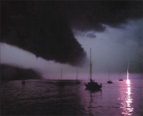
It swells into mounds of thick, billowy cumulous clouds that quickly darken into the towering ominous-looking cumulonimbus clouds characteristic of thunderstorms.
Consider the formation of this thick, dark cloud an unmistakable thunderstorm warning, and head immediately for a safe anchorage. The transition from a small cloud into a turbulent, electrified storm front can occur in as little as 30 minutes. The barometer will drop quickly and strong, gusty winds and heavy rains with thunder and lightning will soon follow. Fortunately, few squalls last more than an hour.
The sharper, darker and lower the front edge of the cloud, the more severe the storm. The anvil-shaped top of the storm cloud points in the direction that the storm is traveling.
In summer, afternoon thunderstorms are likely to occur over water when the humidity and temperature ashore are high. Hot air radiates upward from land surfaces heated by the sun. Moisture from a nearby body of water is absorbed by the warm air, which rises to begin the formation of thunderheads.
They usually appear as swift-moving black clouds, often approaching from the northwest southwest, south or west at speeds of 25-35 knots.
You can determine the distance of an approaching thunderstorm by counting the number of seconds between the lightning flash and the thunder clap, and dividing by five.
That will give you the distance in miles you are from the storm. For example, if the time lapse between the lightning flash and the thunder clap is 10 seconds, divide by 5. The storm is approximately 2 miles away from you.
Another handy tip that a thunderstorm is near is to tune your radio to any AM station. Thunderstorms will create static crackling on a station that would otherwise sound clear.
If a Thunderstorm is Approaching You
- Make sure everyone aboard is wearing a life jacket.
- Secure all loose gear, hatches or ports.
- Determine your location and the best course back to shelter.
- Keep a sharp lookout for the other boats and obstructions.
Once the Storm Hits
- Try to take the first (and heaviest) gusts of wind on the bow, not abeam. Heading into the wind is the most seaworthy position for most small boats.
- Approach waves at a 45 degree angle to keep the propeller underwater, to reduce pounding, and to provide a safer and more comfortable ride.
- If there is lightning, unplug radios and all electrical equipment.
- Stay low. Don’t make yourself the tallest target. Keep away from metal objects that aren’t grounded to the boat’s protection system.
When Lightning Strikes
The best protection against lightning is avoidance. Lightning is random, unpredictable and very dangerous. Here are some tips to help you avoid lightning while on the water.
- The best protection against lightning is avoidance.
- Head into shore well ahead of the turbulence.
- Lightning can lash out for miles in front of a storm, and it can strike after a storm seems to have passed.
- Look for tall clouds that have an anvil shaped top (cumulonimbus) These clouds can be VERY large, reaching several miles high and several miles in circumference. Squall lines preceding cold fronts also produce thunderstorms.
- Listen to NOAA weather reports for storm reports. These reports are available on your VHF radio, and also on some marine stereo systems. If you see lightning, you can determine the distance from you by timing how long it takes for you to hear the thunder. Every five seconds of time equals one mile of distance. If it takes 20 seconds to hear thunder after you see lighting, then the storm is four miles away.
- Approach waves at a 45 degree angle to keep the propeller underwater, to reduce pounding, and to provide a safer and more comfortable ride.
- If there is lightning, unplug radios and all electrical equipment.
- Stay low. Don’t make yourself the tallest target. Keep away from metal objects that aren’t grounded to the boat’s protection system.
- Thunderstorms usually occur where air masses of dissimilar temperatures meet such as over mountains, over inland or coastal waters, or preceding a cold front.
- Air must have a high moisture content (high humidity and a dew point over 60 degrees) and be warm near the ground, such as on a typical summer day.
- When warm ground air rises and meets colder air, it condenses and forms water droplets. Condensing releases energy, which charges the atmosphere, and when the dissimilar charge between the negatively charged surface air and the positively charged highest parts of the cloud gets large enough, an explosion of lightning is created, with up to 30,000,000 volts of electricity.
- Thunderstorms generally move in an Easterly direction, so if you see a storm to the South or Southeast of you, by and large you can rest easy. If you see a storm to the West or Northwest of you, LOOKOUT.
- Turn off as much of your electronic equipment as you can, (unplugging equipment is even better) and try and stay in your boat’s cabin if possible.
For a few first hand accounts of what can happen in a thunder storm, go to the BoatU.S. Insurance Magazine website.
For information on lightning protection, call the Coast Guard InfoLine at 1-800-368-5647, or contact:
National Lightning Safety Institute
891 North Hoover Ave.
PO Box 778
Louisville, CO 80027-0778
Phone: (303) 666-8817
Fax: (303) 666-8786
Weather Information Broadcasts
NOAA Weather Radio operates continuously on the following frequencies:
- 162.400 MHz (channel 1)
- 162.475 MHz (channel 2)
- 162.550 MHz (channel 3)
Your ability to tune in to any particular station depends on your position. NOAA transmitters are placed in frequency order- your ability to receive a weather broadcast for a particular area depends on your location relative to the transmitter. A broad, average range for frequency reception is 20 to 40 miles.
NOAA broadcasts current weather conditions such as temperature, humidity, wave conditions, dew point, barometric pressure, wind speed and direction, and other weather information.
For more severe weather, NOAA uses the following descriptions:
- Small Craft Advisory:Observed or forecast winds of 18 to 33 knots–Small Craft Advisories may also be issued for hazardous sea conditions or lower wind speeds that may affect small craft operations (there is no legal definition of the term “small craft”).
- Gale Warning: Observed or forecast winds of 34 to 47 knots.
- Storm Warning: Observed or forecast winds of 48 knots or greater.
- Tropical Storm Warning: Observed or forecast winds of 34 to 64 knots or higher associated with a tropical storm.
- Hurricane Warning: Observed or forecast winds of 64 knots or higher associated with a hurricane.
- Special Marine Warning: Observed or forecast winds of 34 knots or more associated with a squall or thunderstorm and expected to last for two hours or less.
For boating safety weather rules, see Safe Boating Weather Tips (NOAA PA 94058).
Boating Under the Influence
Drugs and Decisions on the Water
Some Sobering Facts
- About half of all boating accidents involve drugs or alcohol.
- The U.S. Coast Guard estimates the number of non-fatal boating accidents to be 60,000 or higher with property damage well over $240 million annually.
- Each year- from 1961, when statistics were first kept, through 1992- boating accidents have claimed over 800 lives, more than in airplane or train accidents, and have injured thousands more. Waterways are second only to highways as the scene of accidental deaths in the country. The Coast Guard and the U.S. Congress recognize drugs and alcohol as a significant problem on the water.
Boating Stressors
Stressors commonly affecting helmsman and passengers make drinking or drug use while boating even more dangerous than drinking and driving.
Research shows that four hours of exposure to noise, vibration, sun, glare, wind and other motion on water produces a kind of fatigue, or “boater’s hypnosis” which slows reaction time almost as much as if you were legally drunk. Adding drugs or alcohol to boating stress factors intensifies their effects- each drink multiplies your accident risk.
Boating Is More Fun than Driving, Right?
No speed limits, no traffic signals, no merging lanes, no potholes. If you think that makes operating a boat under the influence of alcohol safer than drinking and driving, you could be dead wrong. Alcohol or drug use affects your ability to function in three critical ways. Your balance, judgment and reaction time are affected almost immediately after you start using drugs or alcohol.
A Few Beers Can Put You Under
Alcohol, and drugs also, can have an effect on your BALANCE which can be critical on a boat; simply falling overboard and drowning accounts for at least one in four boating fatalities. When you are “tipsy”, the unstable, moving platform of the boat can easily cause you to fall overboard.
Mary just took her prescription medication. While she is legally able to take her medication, the label warns against using machinery, and also warns against sun exposure. She quickly feels intoxicated, even though she isn’t. She’s pulled over, and receives a ticket for operating under the influence. You don’t have to use illegal drugs to be charged.
Pat was operating his boat while using an illegal stimulant, as he thought it would make him more “aware” of his surroundings. Because of the drugs’ effects, he over-steered his boat and crashed.
Harry is just finishing his second beer. His Blood Alcohol Content is only one-third of what would make him legally drunk. But Harry has “Boater’s Hypnosis” and by drinking only two beers during the last hour, he increased his chances of having an accident.
Will Harry risk an accident or the possibility of a $1,000 federal fine by having another drink? Or will he play it smart and either stop drinking or turn the helm over to a sober skipper?
The alcohol that makes you lose your balance also reduces your body’s ability to protect you against the cold water. With alcohol in your blood, the numbing effects of cold water occur much faster than when you are sober. Within minutes, you may not be able to call for help, swim to a float or reach the safety of the boat.
Additionally, imbibing alcohol can lessen motor function, skew judgment and interfere with decision-making ability. In the event of a fall overboard, it can increase the danger of cardiac arrest and some researchers believe drinking increases susceptibility to inner ear disorientation that is said to cause some swimmers to swim down, instead of up, thus increasing the risk of death or serious injury.
Alcohol and Drugs Can Make a Bad Situation Worse
What else do you lose when you drink or use drugs? Your JUDGMENT. In skills tests, impaired boat operators all reported that they were better operators while intoxicated than sober, despite instrument readings that documented their reduced performance. Alcohol or drugs reduced inhibitions, causing normally cautious people to try stunts or enter high-risk situations a sober person would avoid.
Alcohol Only Makes You Think You Are Perfoming Better
Alcohol severely diminish your ability to react to several different signals at once. With the first drink, brain functions are depressed. It takes longer to receive information from your eyes, ears and other senses, and still more time to react. When peripheral vision, focus and depth perception are impaired by alcohol, it is difficult to correctly judge speed and distance, or track moving objects. Reduced night vision and the inability to distinguish red from green make the intoxicated night boater an even greater hazard.
Fact or Fiction
Myth: Beer is less intoxicating than wine or distilled liquor.
Fact: One 12-oz. beer contains the same amount of alcohol as 5 ounces of 12% wine or 1-1/2 oz. of 80 proof liquor.
Myth: Diluting hard liquor slows the absorption rates.
Fact: Diluting an alcoholic beverage with water or fruit juice slows absorption. Mixing alcohol with a carbonated beverage increases absorption and intoxicates you more quickly.
Myth: A cold shower, coffee, physical activity or fresh air will sober you up.
Fact: Cold showers and coffee will only produce a clean, wide-awake drunk. Only your liver can detoxify alcohol. For each drink you consume, it takes approximately two hours to sober up.
Myth: A shot of brandy or whiskey will warm you up.
Fact: In moderate amounts, alcohol dilates the small blood vessels close to the skin, giving a deceptive “glow” of warmth. In fact, the dilated blood vessels reduce your body’s ability to guard against heat loss.
Myth: You cannot receive a ticket if you are under the influence of prescribed drugs.
Fact: Operating a vessel while under the influence of prescription drugs will make you just as liable.
Myth: Alcohol is a stimulant.
Fact: Alcohol is a depressant. It is absorbed directly into the blood stream through the stomach. As blood circulates through your brain, the alcohol depresses body functions and learned restrictions on social behavior. Judgment, balance, vision and reaction time are affected almost immediately.
How To Stay Alert and Avoid Hazards on the Water
- Limit your alcohol consumption to one drink or less per hour.
- Be aware of the effects of alcohol, both on and in the water. Remember that boating stress factors alone will reduce your ability to function.
- If you expect to have more than one or two drinks per two-hour period, allow a non-drinker to operate the boat.
- Even drugs that are stimulants can have an adverse impact on your ability to operate a boat properly.
- Better yet, don’t go boating. A responsible boater will refuse to allow an intoxicated or impaired person to take the helm.
Operation of a boat while intoxicated is a federal offense, subject to a $1,000 fine. The current federal legal limit is .08% Blood Alcohol Content. Criminal penalties are as high as $5,000. Many states are toughening their “Boats and Booze” laws by stiffening penalties and boosting law enforcement efforts. Most states also restrict operating “under the influence”. Operating under the influence has a lower threshold Blood Alcohol Content–usually .05%. However, you may be charged with operating under the influence at any point–it is at the discretion of the boating officer based on their perception of how you are functioning as a boat operator.
Banning alcohol from boats is not practical. But moderation and common sense on the water are very practical. When you operate a boat, you accept responsibility for the boat, for the safety of your passengers and crew and for others out enjoying the water.
Drugs and alcohol aren’t the sport. Boating is the sport. Enjoy it safely.
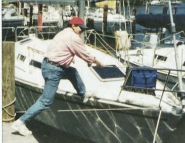
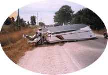
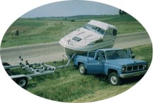
Boat Transportation & Trailering
Roll Your Boat – All About Trailering
Mention a skipper’s boat, and he or she is liable to talk about itsgraceful sheer, its quickness, the way it handles, or the clever use of space below.
Mention a trailer, and the first thing that comes to mind is convenience. While the marina-based boat is restricted by time, distance, and the weather, a trailered boat can be transported just about anywhere—lakes, oceans, bays, or inlets–in the span of a weekend. Hurricane coming? Put the boat on its trailer and head inland. Too cold? Head south.
But convenience is only part of a trailer’s appeal. When you consider the money saved on slip fees, bottom paint, and blister repairs, it’s easy to understand why trailer boating is so popular.
Boating on a highway, like boating on the water, requires some attentiveness and know-how. That’s what this brochure is all about. Boats go aground in the water. Boats can also “go aground” on a highway. Negotiating stoplights, potholes, slick spots, and manic vacation traffic while towing a cumbersome trailer and boat takes practice.
Trailers, like boats and automobiles, require TLC to keep them rolling. But no amount of maintenance will help a trailer that is too small, or otherwise inadequate, for the boat it will be towing. The first step, then, is to choose a trailer that is most likely to get you and your boat where you want to go, despite potholes and vacation traffic.
Part I: Selecting a Trailer
With a modern boat, the choice of a trailer is often left to the dealer, which means bunkers or rollers will be positioned properly to provide maximum support. It is a no muss, no fuss deal for the buyer. He or she has to rely on the trailer dealer, however, and dealers have been known to unload inventory that may not be entirely suited to your needs. In this case, it helps to know what your needs will be and what options are available to meet those needs.
Trailer Size
After spending a small fortune to buy the boat of your dreams, it may be tempting to skimp a little on the trailer. Don’t. A trailer that is too small is more than just an inconvenience, it’s dangerous. Federal law requires that a trailer display its GVWR (Gross Vehicle Weight Rating), which is the total weight the trailer is rated to carry, including the boat, engine, gasoline (six pounds per gallon), water (eight pounds per gallon) and gear.
Some experts suggest that as a margin of safety the total weight of the boat and gear be no more than 85% of the trailer’s GVWR. Don’t confuse the GVWR with the GAWR, which is the load carrying capacity of an axle – its Gross Axle Weight Rating. On single axle trailers, the GVWR and the GAWR are the same. For tandem-axle trailers, the GVWR is equal to twice the GAWR.
Single vs. Tandem-Axle
While they cost more and require more upkeep, boat owners who have traded-up to tandem axle trailers almost always report that they are pleased with the results, especially with larger boats. For one thing, tandem trailers handle better, with better tracking and less tendency to fishtail. The extra wheels also mean a much smoother ride and safer handling in the event of a blowout. The size of the tires—larger is better—also contributes to the smoothness of the ride. It is usually easier to find replacements for larger tires, although you shouldn’t make the mistake of substituting an automobile tire for a trailer tire. Trailer tires have thicker sidewalls.
Submersible or Float-on Trailers vs. Roll-Off Trailers
Submersible trailers, which allow the boat to float free when the trailer is submerged, have the advantage of being easier to use, at least for beginners. The disadvantage is that submersible trailers require more upkeep and a steeper ramp for launching. Some trailers tilt to create a steeper launch angle but are usually unwieldy for all but the smallest boats.
Roll-off trailers may be easier to maintain, but they are also more expensive-about 20% more. And for the inexperienced trailer owner, roll-off trailers can be more difficult to use. A skipper in Michigan who said he had used a submersible trailer several times still managed to do several hundred dollars worth of damage to his new boat when it rolled too quickly off his new trailer and bashed onto the concrete ramp in shallow water. As a general rule, rollers make launching and retrieving easier, while pads provide better support for the boat. Many trailers now use a combination of pads (at chines) and rollers (at keels) to optimum advantage.
Paint vs. Galvanized
Many manufacturers offer a choice of a galvanized steel or painted steel trailers. The painted trailers are fine for freshwater but are vulnerable to corrosion in saltwater. Galvanized trailers cost slightly more, but require less maintenance, especially if they will be dunked in saltwater.
Painted trailers are sometimes painted to match the boat, which is nice. With galvanized trailers, one expert suggests painting it with bright colors, especially colors that clash, so that it will be easy to identify. Not a bad idea. The BoatU.S. Marine Insurance claim files have shown that a boat on a trailer is far more likely to be stolen. If you were a crook, which trailer would you steal: one that looks like every other trailer on the road or one that looks like a painted circus wagon?
Trailer Brakes
In many states, trailers with a GVWR of 1,500 pounds or more are required to have brakes on all wheels. Most automobile manufacturers suggest trailer brakes be used with even lighter weights.
There are two basic types of brakes on trailers: surge brakes and electrically-activated brakes. Most trailers have surge brakes, which are activated after the automobile’s brakes have slowed the trailer. Surge brakes are frequently wrecked by dunking, although newer models have flushing devices that offer some protection. Electric brakes, which are connected to the automobile’s brakes, are also vulnerable to dunking.
Trailer Hitches
Trailer hitches are rated in four classes according to the weight (GVWR) they will be pulling: Class I has a maximum capacity rating of 2,000 pounds; Class II has a maximum rating of 3,500 pounds; Class III has a maximum capacity rating of 5,000 pounds; and Class IV has a maximum rating of 10,000 pounds. The weight of your boat, trailer, and gear should never exceed this capacity.
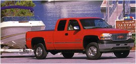
Another Consideration: The Tow Vehicle
A tow vehicle’s engine, transmission, cooling system, tires, and rear springs are all stressed by the additional weight of a boat and trailer. Considering that the average price of a new tow vehicle starts at about $20,000, it behooves the trailer boat owner to be mindful of the vehicle’s towing capacity and to select a vehicle with a towing capacity that is at least several hundred pounds greater than the weight you intend to pull.
Always follow the manufacturer’s recommendations when an automobile or truck is used for towing a boat. Don’t assume a big car can be used to haul a big boat. A Cadillac Seville with a hefty 4.6 liter V-8, for example, has a rated towing capacity of only 1,000 pounds, which is the same towing capacity as a tiny Ford Escort.
And while horsepower is certainly important, more horsepower does not always produce more torque. The latter is a measure of how much weight an engine can move. An automatic transmission is more desirable for towing than a manual transmission, since the added weight is tough on a clutch.
Auto manufacturers publish a recommended towing weight, which, depending on the type of construction, is usually about half the weight of the car. Although the car will be able to haul more weight, exceeding the recommended towing weight will make the trailer difficult to control and cause the car to get old before its time.
Since you’ll have passengers, luggage, etc., in addition to the boat, manufacturers now use a gross combined weight rating (GCWR), which is the total weight of the car, trailer, boat, passengers, and gear that a car can safely accommodate.
Many automobile manufacturers offer optional beefed-up towing packages. The additional cost on a new car is nominal, and is certainly worth the money if you plan on towing a boat. If you’re not going to buy a new car anytime soon, and your present car is too feeble to tow the family boat and trailer, you may be able to bring it up to snuff by beefing up the spring coils with air bags, adding a larger radiator and water pump, etc. This will be considerably more expensive than ordering the same components on a new car, but it can be done by most car dealers.
Part II: Trailer Maintenance
Three things dictate how often a trailer needs to be inspected: where it is used; how often it is used; and how hard it is used. A fourth consideration, just to complicate the discussion, might be the quality of the trailer itself. As a bare-bones minimum, any trailer should be thoroughly inspected at the start of each boating season.
Even if the trailer isn’t used regularly, an annual inspection and any subsequent maintenance will protect its value. If a trailer is going to be used frequently, will be dunked in saltwater, and will spend many hours traveling over bumpy roads, you’ll want to inspect key components much more often. Here are a few tips and suggestions.
The Frame and Axle
Submersible trailers have the advantage of being easier to use, at least for beginners, but they have the disadvantage of requiring more upkeep, especially when the trailer is used in saltwater. Any light rust on the trailer’s frame should be sanded and painted. The sooner the better. If a structural component appears to be badly rusted, the trailer shouldn’t be used until it is examined by an expert or the component is replaced. To prevent rust, even a trailer with a galvanized frame should be rinsed thoroughly when the trailer has been dunked in saltwater.
Trailers tend to get bounced around a lot, and any loose nuts on the frame must be tightened. If you aren’t familiar with your trailer, structural components should be inspected frequently until you’re confident that none are prone to loosening. Even the tightest trailer should be examined routinely on long trips.
Trailer Brakes
Surge brakes must be adjusted periodically. You’ll have to jack the wheel off of the ground and then use a tire tool to first tighten the adjustment cog all of the way until the wheel won’t turn and then back it off a few turns until the wheel again turns freely. If you do the job yourself, follow manufacturer’s recommendations.
Trailer Tires
A blown tire can be more than just an inconvenience. According to the BoatU.S. Marine Insurance claim files, neglecting tires is one of the most frequent causes of trailer failure–broken axles and even spilled boats. Treads should be examined whenever the trailer will be used, but keep in mind that trailer tires sometimes need replacing long before the treads wear out. Spider-web cracks on the sidewall are an indication that the tire is rotten and can’t be relied on to carry heavy loads. While you’re examining the sidewalls, take a look at the wheel to make sure they’re tight.
Sidewalls contain another useful bit of information: the max load limits for the tires. If there are two tires rated for 500 pounds each, then the total weight on the trailer–the boat and gear–should be no more than 1,000 pounds.
Trailer tires frequently suffer from under inflation and should be checked whenever the trailer is used. Recommended inflation pressures are stamped on the sidewalls. Monitoring inflation pressure (when tires are cool) is especially important on trailer tires, which are typically smaller and work harder than automobile tires. An under-inflated tire builds up heat quickly, which can cause the layers inside –called plies–to delaminate. Repair or replace a tire with a slow leak. Never mix tires–bias plies and radials. Use tires built specifically for use on trailers, which have thicker sidewalls.
Trailer tires deteriorate in sunlight and can have their useful life extended by taking them off the trailer and storing them in the garage (put blocks under the trailer frame) whenever the trailer will be idle for extended periods. Removing the tires also discourages theft. If removing the tires isn’t possible, wrap them in plastic trash bags to protect the sidewalls from sunlight.
Trailer tires frequently suffer from under inflation and should be checked whenever the trailer is used.
Spare Tires, Hassles, and Highway Theft
Considering what is at stake, it is surprising how many skippers do not carry a spare tire for their trailers. Trying to find someone who can fix (or replace) a blown trailer tire can be a hassle, to say the least, but there is also a considerable risk that while you’re searching for a gas station someone will steal the boat. A boater in Connecticut, to use one example, left his trailer on the side of a busy highway for less than a half-hour while he went to get the tire repaired. When he got back, the boat and trailer were gone. Another boater, this one in Texas, left his boat and trailer to get a tire repaired and returned sometime later to find that his outboard was missing. After leaving briefly to report the theft to police, he returned to find that the boat and trailer (and his luggage) had disappeared.
Boats on trailers are an easy target for thieves, especially when they’re sitting alone on the side of a busy highway. Learn from the mistakes of others: carry a spare tire for your trailer! A U-bolt can be used to attach the spare directly to the trailer frame. Note: A typical car jack will not work on a trailer, so you’ll need to get a scissors jack that is large enough to handle the load.
Hubs and Bearings
If your hubs don’t have bearing protectors, it is best to keep them out of the water. If you must dunk the hubs, allow time for them to cool or cold water will be drawn inside, displacing the grease and causing the bearings to corrode and fail. Bearings that have been accidentally submerged in saltwater should be cleaned with kerosene and then butyl alcohol before being repacked with grease. Use something like a tongue depressor to distribute the grease evenly to both front and rear bearings (don’t over-pack). With most hubs, seals must be replaced whenever they’re removed for packing.
Most new trailers, fortunately, have bearing protectors, which are metal caps with springs that hold grease under pressure. These protectors eliminate water penetration into the hub, not to mention a lot of grubby work. If your trailer doesn’t have protectors, they can be and should be added to the hub. They’re easy to install and are relatively inexpensive.
With protectors, a squirt or two of grease at a fitting is all that is required to protect bearings. Press the protector at the edge; if it moves it doesn’t need grease. If it is rigid, you’ll need to add grease (use only a grease recommended for trailer bearings). Even with protectors, it is a good idea to carry extra bearings on a long trip.
Lights and Electrical
Boat trailers are required to have lights, but not all trailer lights are waterproof. Some trailer lights aren’t meant to be immersed in water and should be removed before launching. Even if you have sealed trailer lights, don’t let the connector plug to the car get dunked, especially when it’s still connected. Only stranded copper wire, which is flexible and break resistant, should be used on a trailer. Exposed wire should be secured every 18″ to prevent chafing. The entire system should be inspected twice a year for bare or chafed wires and all of the contacts given a protective dab of grease. Finally, it’s a good idea to always carry spare bulbs and fuses.
Rollers
Rollers that are damaged should be replaced. The yellow or clear “poly” rollers, incidentally, last considerably longer than their rubber counterparts, which deteriorate in sunlight.
Winch
In general, your winch should be rated to pull at least half the combined weight of your boat, motor and gear. Check your winch regularly for loose mounting bolts and any loose internal parts. If you use an electric winch, check that the power cord is in good shape and there is no corrosion on the wire–you might over heat the winch if the electricity supply isn’t 100%. Make sure your winch line doesn’t rub up against anything while loading and unloading the boat. Check the line frequently for wear or fraying. Even a slight amount of wear can significantly reduce the weight carrying ability of the strap.
Note: Winches are designed for one thing: loading and unloading your boat. They are NOT designed to hold your boat on the trailer when you are going down the road. Make sure you use other methods of securing your boat to the trailer!
Part III: Towing a Trailer
Weight Distribution
Driving hazards that are normally only an annoyance to an automobile – potholes, uneven pavement, sharp curves, etc.—can be scary when you’re towing a trailer, especially if the weight is not distributed correctly. Five to 10 percent of the total weight of the boat, motor, trailer, and gear should be on the trailer ball when the coupler is parallel to the ground.
Too much weight on the ball and the car will be difficult to steer (and good luck retrieving your boat at a steep launch ramp, especially if your car has front-wheel drive). You can also wreck the car’s suspension system. Too little weight on the ball and the trailer is prone to fishtailing – excessive swaying from side to side. Fishtailing can also occur when tires are too soft or the trailer and the boat are too heavy for the car.
Techniques for redistributing weight at the coupler include shifting gear inside the boat, emptying water and fuel tanks, and adjusting the boat’s position on the trailer. If all else fails, you can remedy the problem by moving the trailer’s axle – a much larger job that usually requires a pro.
Positioning the Boat
Many boats spend the better part of their lives atop a trailer. To reduce the chances of sagging or oil-canning (flexing) that could permanently disfigure or even weaken the boat’s hull, the boat should always be level and supported evenly, with rollers or padded bunks concentrated in critical areas such as the engine and chine. On boats with outboard or I/O’s, transoms must be well supported. Poly rollers, incidentally, last considerably longer than their rubber counterparts, which deteriorate in sunlight.
Securing the Boat
Keep in mind that when you’re barreling down the highway at speeds of 65 mph or more, the boat will be buffeted by near hurricane force winds.
Anything loose on the deck or in the cockpit, including things like Bimini tops, will probably be blown away. Either stow them below or make sure they are secured. Better yet, wrap the boat in a snug-fitting cover, which protects the upholstery from sunlight and road grit, as well as reduces fuel consumption.
A heavy strap should always be used to anchor the boat’s stern to the trailer. If a strap isn’t used, the boat will bounce against (or off) the trailer. Don’t rely solely on the winch cable to tie down the bow. Use a separate line from the bow eye down to the trailer. When you’re traveling, check the straps and the bow eye itself whenever you stop.
Safety Chains
Always use a safety chain, criss-crossed between the car and the trailer coupling. Should the hitch fail, heaven forbid, the chain will keep the trailer from flying off the road. Crossing the chain prevents the trailer coupler from separating completely from the car. Leave enough slack in the chain to allow for proper turning, but not so much that it drags. Using a shackle/pin is far more secure than relying on the standard S-hooks, which have been known to jiggle loose.
Launching and Retrieving the Boat
Getting There (In One Piece)
The first thing you should remember when towing a trailer is that you are towing a trailer. That may sound obvious, but when the car is humming merrily along it can be easy to forget the trailer is back there. Slow down! Reducing speed gives you more time to react and reduces the strain on the car and trailer. Swing wider at corners so your trailer doesn’t hit the curb, and remember to allow extra space when you pass other cars.
The additional weight of a trailer dramatically affects braking, so leave considerably more distance than you normally would between your car and the car in front of you.
Rely on lower gears rather than brakes to reduce speed when driving downhill. Some states have separate speed limits for cars pulling trailers, and you should also be alert to signs restricting trailers.
On trips, make it a habit to check the wheel hubs every time you stop for gas. If one hub feels hotter than the other, or if both feel abnormally hot, the bearings should be inspected before you continue the trip. Straps holding the boat, lug nuts on the tires, and structural nuts and bolts on the trailer frame should also be examined to make sure they’re tight. If it is raining, check the boat’s cover for pooling water, which could affect weight distribution and make the car more difficult to handle.
Launching the Boat
Let’s suppose you’ve managed to negotiate the gauntlet of potholes, slick spots and traffic snarls without mishap. The trailer held together. You have arrived at the launch ramp.
If the ramp is crowded, and it usually is on weekends, don’t despair; use the extra time to prepare your boat and trailer before it is your turn to launch. Make sure the lower unit is raised to avoid scraping; install the drain plug; release the securing straps; disconnect the trailer’s lights; and rig a line so the boat doesn’t drift away after it is launched.
If you are stepping a mast, make sure there are no overhead power lines between you and the ramp. If you don’t have bearing protectors, make sure hubs are cool.
Next, you’ll have to back the trailer onto the launch ramp. To a novice, backing a trailer can be like standing on your head and reading a book upside down in a mirror. It takes practice. Learning can be rough on the blood pressure – yours and the other people at the ramp waiting patiently (or impatiently) to launch their boats.
To avoid disagreeable encounters with your fellow boaters, practice backing the trailer in the quiet safety of your driveway or, better yet, an empty parking lot. Tip: push the bottom of the car’s steering wheel in the direction you want the trailer to go.
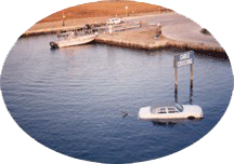
Keep a tire stop handy, leave the car’s engine running in case you need power quickly, and don’t forget your parking brake! That may seem elementary, but when a particular boater in Tennessee got careless, his truck and trailer rolled down the ramp and didn’t stop until they were in 60′ of water. It must have been a long walk home.
Retrieving the Boat
Now that you’ve enjoyed your time on the water, it’s time to go home. When you get to the ramp, good manners are very important! If there are other boaters launching or leaving, you must wait your turn. When your turn comes, you must be ready to move quickly. Start by getting all of your gear ready to take off the boat, and get your boat ready to go on the trailer. If you have the option, let someone off the boat to get the trailer to the water while you or the other people aboard take the gear off. at the ramp waiting patiently (or impatiently) to launch their boats.
Before you back down the trailer, make sure the trailer lights aren’t connected to the tow vehicle. If the trailer has a tilting trailer bed, put it in the up position. Slowly back the trailer into the water, and use the boat’s bow and stern lines to line the boat up with the trailer. at the ramp waiting patiently (or impatiently) to launch their boats.
Attach the winch cable to the boat, and start cranking! Be careful that no one is in the direct line of the winch cable–if it breaks you can be seriously injured from the whiplash. After you have the boat all the way on the trailer, attach the safety chains and pull the boat the trailer forward–make sure your engine is raised first! at the ramp waiting patiently (or impatiently) to launch their boats.
Once you’ve cleared the ramp area, make sure all lose gear is stowed, attach the tie-down straps, and reconnect the trailer lights to the tow vehicle, and hit the road. at the ramp waiting patiently (or impatiently) to launch their boats.
NOTE – While many people drive the boat onto the trailer, it isn’t advised. Using the engine to assist trailering erodes the ramp bed, can lead to debris being sucked into the engine, and can cause an accident!
Make sure you drain all water from the boat – the bilge, the live well, the trailer lights, etc. Trailer boats are a leading cause of the spread of invasive species. Make sure your boat is cleaned thoroughly before you launch your boat again, particularly if you go to a different body of water. The best thing to do would be to clean your boat at the ramp. If you can’t, try to make sure that when you do wash, the water doesn’t go into a drain that feeds into a sewer that feeds into a different body of water.
Protecting Trailers from Thieves: A Few Suggestions
Wayne thought he was being prudent bringing his boat home for the winter. His marina wasn’t in an especially good neighborhood and, besides, nobody would watch after his boat the way that he would. You can guess the rest. Despite Wayne’s caution, he returned from work late one afternoon to an empty driveway. His boat had been stolen.
It’s no wonder that trailer boat thefts appear so frequently in the BoatU.S. claim files. Imagine leaving thousands of dollars stored in large crates marked MONEY on a trailer in your driveway. An exaggeration? Maybe. But to a thief, especially a professional, a boat on a trailer is not much different than a stack of dollar bills. Simply parking a boat in a driveway in front of your house offers little or no security. But there are a few simple tricks, shown below, that will make a boat on a trailer a much less attractive target for thieves.
- Remove the tires. This not only makes it much harder to pull the trailer, storing the tires indoors (out of the sunlight) prolongs their life and reduces the chances of a flat tire. As an added precaution against theft, be sure to remove the hub nuts and store them with the tires.
- If practical, chain the trailer to a tree.
- If possible, store the boat in the backyard or in the garage so that it can’t be seen by passers-by. If the boat has to be stored in the driveway, don’t leave the trailer hitch facing the street. Even if the hitch is locked or has been removed, professional thieves carry coupler devices that can be quickly attached to the trailer.
- Remove the trailer’s license plate and, if possible, the tail lights.
- Invest in a dog, preferably one with a nasty disposition to deter strangers.
- Locks are available for props and some model out drives. Smaller outboards should be taken off and stored in the garage.
For More Information About Trailering
- Check out BoatUS information on trailering
- Check out Seaworthy Magazine information on trailering
Fueling
Proper Fueling Procedures
Proper fueling procedures are very important in preventing onboard fires. Gasoline vapors are heavier than air and can spread rapidly into enclosed spaces. You should check the bilges and all closed compartments for gasoline vapors. The sniff test is the most effective method for detecting fuel leaks.
The proper way to fuel your boat is as follows:
- Secure boat to the dock
- Switch off engine
- Extinguish all open flames
- Do not use electrical switches
- No smoking
- Ports, hatches, and doors closed
- Make certain all passengers are ashore
- Determine quantity of fuel required and make sure it is the proper type of fuel
- Hold hose nozzle firmly against fill pipe opening
- Do not overfill
- Wipe up all spillage
- Open ports, hatches, and doors to ventilate
- Turn blower on for four minutes minimum
- Do the sniff test
- Start engine
- Re-board passengers
- Untie from dock and cast off
Proper fueling techniques also keep our water clean and safe, and help marine life thrive in a healthier environment. You are legally required to report fuel spills, and to take prompt action to clean up any spills that may occur.
Under federal law (the Oil Pollution Act of 1990 and the Clean Water Act) it is illegal to discharge any petroleum product into the water. By law, any oil or fuel spill that leaves a sheen on the water must be reported to the U.S. Coast Guard at 1-800-424-8802.
You are responsible for any environmental damage caused by your fuel spill. So…preventing spills will be beneficial for you and the boating environment.
It is also against the law to use detergent or other chemicals on a spill to disperse the oil or sheen. These products can cause the petroleum to sink into the water, causing more harm to marine animals and bottom sediments.
If you have spilled a petroleum product, immediately stop the source of the leak, use oil absorbent pads or booms, and notify your marina. Call the U.S. Coast Guard. Your marina may also know a state agency that needs to be contacted. If the spill is of any substantial size, we also recommend you call your insurance company.
For portable tanks do the following:
- Tanks six gallons and smaller should be removed from the boat.
- Add appropriate amount of oil for 2-cycle outboards to fuel tank.
- Make sure hose nozzle is in contact with rim of tank.
- After filling, secure tank to the boat so it will not slide around while underway.
Few Fuel Conservation Tips
- Keep engine well tuned.
- Use the correct propeller and check for damage.
- Be sure engine is adequate for boat.
- Use proper oil mix in motor.
- Keep hull clean to reduce friction.
- Drain all water before leaving dock.
- Distribute weight evenly and don’t overload.
Fuels and Fumes
For many boaters, an enjoyable time on the water includes having all of the creature comforts that they are used to having at home such as hot water, heating and cooling, and a stove or grill. While having these items may make for a more enjoyable cruise, they must be handled much more carefully on a boat, and may operate very differently from their shore side counterparts.
Hot water heaters, stoves, grills, air conditioners and heating systems all need fuel to operate. Types of fuel include electricity, alcohol, Compressed Natural Gas (CNG), Liquid Petroleum Gas (LPG-propane or butane), charcoal, kerosene, and diesel. Each fuel has specific characteristics, both pro and con, that you need to know before you use it for a particular piece of equipment.
Pros and Cons:
CNG-Compressed Natural Gas is natural gas liquefied under high pressure. (approx. 2250psi) CNG fumes can combine with oxygen to form a powerful explosive. Though CNG fumes are lighter than air and will generally dissipate through open ports and hatches, care must be used with CNG appliances. Manufacturers include additives in CNG to make it smell strongly. Nothing beats a nose to sniff out gas fumes!
LPG – Liquefied petroleum gas is really two different gases that are generally classed together and are interchangeable. Propane and butane are both used in LPG appliances and have some advantages over CNG. LPG has a much higher heat output (21,000 BTUs/lb. for LPG vs. 9,000 BTUs/lb. for CNG) LPG also operates at lower pressures.
One thing to note, if you boat in cold weather, propane is preferable to butane, as butane has difficulty vaporizing in extremely cold weather and might not allow an appliance to work properly. One drawback to LPG is that fumes are heavier than air, and can build up to dangerous levels in bilge compartments. Even a small spark can signal the end of your boat!
Kerosene is also used on boats for heating, lighting, and to a lesser extent, cooking. Kerosene must be totally clean for it to work properly, and the whiter the kerosene the better. If you have yellow kerosene DO NOT use it in your burners, as it may clog your burner with carbon deposits.
Alcohol is used largely for stoves and is a relatively safe fuel. Denatured ethyl alcohol does not burn very hot- it may take quite some time to boil water on an alcohol stove. One of the best aspects of alcohol is that a flame can be put out with water. Like kerosene, alcohol must be clean for an appliance to work properly.
Electricity is probably the safest “fuel” that you can use on a boat. There are no explosive fumes, no pressurized fuel system that can develop dangerous leaks.
Electricity’s main drawback is the large amount of current most appliances need to operate properly. Large current demands that many appliances need require boats to be hooked up to shore power or to have a generator.
All fuels must be properly stored on a boat. Safety devices such as fume sniffers should be considered for boats equipped with any gas system. Remember, gasoline should NEVER be used to fuel any on board appliance other than a generator or main engine. Gasoline is extremely volatile and its fumes are deadly.